Departments
Contact Info
City Hall
60 South Main Street
P.O. Box 48
Driggs, Idaho 83422
Hours: Monday-Thursday 8:00 a.m. - 5:00 p.m.
Closed Fridays and Federal Holidays
Phone: (208) 354-2362
General Email: info@driggsidaho.org
Planning & Zoning Applications
Find application requirements, checklists, fees, procedures, and other information for planning and zoning applications in the City of Driggs.
Application requirements and review procedures vary by application type. Use the expandable sections below and Chapter 14 of the Land Development Code to determine the requirements that apply to your application.
Looking for maps, regulations, plans, or other planning and development resources? Visit the Planning & Building Resources page.
Use the information below to access submission requirements, fees, applications, standards, and related planning and development resources.
Application Requirements & Information
Information and requirements for land use and zoning applications.
The following requirements apply to ALL land use and zoning applications and submissions.
Application Submittal Checklists
Download the applicable checklist before submitting an application or resubmittal. A completed and signed checklist must be included with each submission.
Plans and Drawings
All submitted plans must be digitally drawn to scale by a professional. See the Site Plan Standards Checklist for applicable requirements.
BEFORE YOU SUBMIT: review the Important Requirements for All Applications section above.
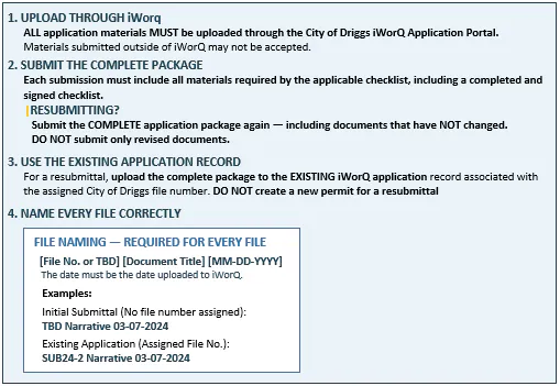
Applications are submitted through the City’s online application portal. Instructions for accessing the portal and submitting an application are provided below.
New Applicants
Start a new application through the City of Driggs iWorQ Application Portal .
Existing Applicants
To upload additional documents or respond to staff requests for an existing application:
- Log in to the City of Driggs iWorQ Application Portal using your contractor code. If you do not know your contractor code, contact candersen@driggsidaho.org for assistance
- Click the 🔍 magnifying glass icon to search for an existing application.
- Locate and select the application record associated with your City file number.
- Upload the required documents to the existing application record.
For resubmittals: Do not create a new application. Upload the complete package to the existing application record.
Need help accessing your application or uploading documents? See the How to Access Your Permit & Upload Application Materials guide.
Plans and Drawings
All submitted plans must be digitally drawn to scale by a professional. See the Site Plan Standards Checklist for applicable requirements.
Additional Requirements – Project Specific
Depending on the application and scope of the project, additional requirements may apply, including Area of Impact requirements, Qualified Workforce Housing Incentive Program (QWHIP) requirements, Water Source Capacity Mitigation requirements, and external agency requirements.
See the applicable sections under Project-Specific Requirements below for more information.
Application fees are established in the City of Driggs fee schedule and are subject to periodic updates.
In addition to minimum fees, the City may charge the applicant publication, filing, postage, & City staff time that exceeds the prescribed application fee.
FY26 fees effective October 1, 2025; amended February 3, 2026
Payment: Application fees may be paid by cash or check in person at City Hall or by mail to:
City of Driggs
P.O. Box 48
Driggs, ID 83422
Include the applicable iWorQ Permit # or assigned file number with your payment.
Meeting Dates & Deadlines
Refer to the Meeting Dates & Deadlines Calendar for recommended submittal dates and upcoming meeting dates.
Recommended submittal dates are provided as a general guide. Placement on a meeting agenda is not guaranteed and may be affected by factors such as required public notice and meeting schedules.
Neighborhood Meetings
Applications that require a neighborhood meeting will not be scheduled for a public hearing until the required neighborhood meeting has been held.
A minimum of three (3) weeks' notice is required to schedule a neighborhood meeting.
Public Hearings
Applications requiring a public hearing must meet the applicable submittal and noticing requirements before being considered for a public hearing.
Neighborhood meetings are required for certain applications, including:
- Large Scale Subdivisions
- Zone Map Amendments that change a residential zone to commercial or industrial, or increase the allowed residential density
- Annexation requests
For Large Scale Subdivisions, the neighborhood meeting is held after Concept Plan submittal and before Preliminary Plat submittal, unless another order of applications is appropriate.
Applications requiring a neighborhood meeting will not be scheduled for a public hearing until the required neighborhood meeting has been held.
A minimum of three (3) weeks' notice is required to schedule a neighborhood meeting.
For required neighborhood meetings, the applicant will work with City Staff on the meeting date, time, and location, as well as the sign-in sheet and meeting summary. City Staff will provide notice of the meeting to nearby property owners.
Project-Specific Requirements
Requirements that may apply to your application based on the location, scope, or type of project.
QWHIP Requirements:
A Workforce Housing Plan is required with any application requesting QWHIP incentives.
QWHIP applies to the following types of development:
- Full plat subdivisions
- Short plat subdivisions
- Annexations and zone changes
- Townhomes
- Condominiums
- Site Development Permits
Refer to the Qualified Workforce Housing Incentive Program page for additional information and program resources, including the QWHIP Guidelines and QWHIP Administrative Procedures.
Developers and subdividers proposing to connect to the City of Driggs water system must offset the impact of their development on water source capacity.
A Water Mitigation Plan Application must be submitted with Preliminary Plat Applications and/or Site Development Permit Applications.
Development containing fewer than 25 Equivalent Dwelling Units (EDUs) may pay a fee in lieu of conveying water rights.
Refer to the Water Source Capacity Mitigation page for information on water rights and the Water Mitigation Plan Application.
The Area of City Impact (AOI) is an area of unincorporated Teton County land jointly defined and adopted by the City of Driggs and Teton County. Properties located within the AOI are subject to specific plans and regulations established by the City of Driggs and Teton County for planning and zoning within the area.
Determine Whether a Property Is Within the AOI
Use the Teton County GIS Zoning Map to determine whether a property is located within the Area of City Impact. The map can also be used to view zoning, overlays, and City limits.
Refer to the Area of City Impact Information page for the current AOI boundary, regulations, maps, and additional information.
Additional requirements or coordination with outside agencies and service providers may apply depending on the location and scope of a project.
Grand Teton Canal Company (GTCC): Required Approvals
Approvals must be obtained from the Grand Teton Canal Company for all properties that intersect with or impact the canal.
Refer to the Grand Teton Canal Company Information page for requirements, fees, approval checklists, and application forms.
Eastern Idaho Public Health (EIPH): Will Serve Letter Requirement
For plats requiring EIPH signatures, a Will Serve Letter is required for any project proposing connection to the City of Driggs water and/or sewer system.
Refer to the EIPH Land Development page for additional details and submittal requirements.
RAD Curbside: Front Load Dumpster Enclosure Requirements
RAD requires a specifications and requirements packet to be completed and returned to RAD for design approval.
Refer to the RAD Information page for additional details and the packet.
Other Service Providers and Agencies
Applicants may also need to coordinate with other agencies or service providers as applicable to their project.
Applications by Type
Forms, code references, fees, and other information specific to each application type.
An owner of property that is contiguous to current city limits AND lies within the Driggs Area of Impact may apply for annexation to become part of the City of Driggs. All annexation applications are subject to the requirements, review process, approval criteria and other stipulations found in Article 14.10 of the Land Development Code. An ordinance specific to the annexation will be adopted if the application is approved.
Application Fees - fee by acreage below:
5 Acres or less - $2,485
6-20 Acres - $2,995
>20 Acres - $3,200
Application Submittal Checklist - must be uploaded with all submissions
Submitted Plans must be digitally drawn to scale by a professional - See the Site Plan Standards Checklist
Water Source Capacity Mitigation Requirements:
Developers and Subdividers must complete and submit the Water Mitigation Plan Application at the time of Site Development Permit application.
Refer to the Water Rights Mitigation Information page for details on how to transfer water rights and for the Water Mitigation Plan Application .
Qualified Workforce Housing Incentive Program (QWHIP) Requirements:
Developers and Subdividers must complete and submit a Qualified Workforce Housing Plan with any application requesting QWHIP incentives, including Site Development Permits. Refer to the Qualified Workforce Housing Incentive Program page for details.
Code References:
Article 14.10 Annexation process & criteria
Idaho Statute 50-222 provides the legal framework for cities to take jurisdiction of zoning in annexed territory and establishes hearing procedures.
Application Submittal Checklist - must be uploaded with all submissions
Application Fee: $1,320
A Boundary Line Adjustment process is required when adjusting or removing common property lines or boundaries between adjacent parcels or tracts. Purposes for the adjustment may include (but are not limited to) accommodating a transfer of land, combining existing parcels or rectifying a disputed property line location. Only adjustments between building lots are eligible for review under this process; those that affect roads, parks, etc. are subject to the Plat Amendment Process.
Application Fee: $465
Application Submittal Checklist - must be uploaded with all submissions
Submitted Plans must be digitally drawn to scale by a professional - See the Site Plan Standards Checklist
Boundary Line Adjustment Application Form
Code Reference
Section 14.13.3 of the Land Development Code outlines the application requirements, approval criteria and review process for a boundary line adjustment.
Only those uses identified in the Use Table (Article 10.2) as requiring a Conditional Use Permit (CUP) are eligible to apply for a CUP. The intent of the CUP is to provide standards and oversight to mitigate the effects these uses may have on the public and surrounding land owners. If the proposed conditional use cannot adequately meet the conditions necessary to assure protection and compatibility with the surrounding properties, uses and neighborhood, the Planning & Zoning Commission will not approve the proposed use.
Application Fee: $1,740
Application Submittal Checklist - must be uploaded with all submissions
Submitted Plans must be digitally drawn to scale by a professional - See the Site Plan Standards Checklist
Conditional Use Permit Application
Code References:
Driggs' Land Development Code Use Table in Article 10.2 shows the eligible conditional uses in each of the city's zoning districts.
Article 14.7 defines the Conditional Use Permit approval criteria and review process.
Idaho Statute 67-6512 provides the legal framework for conditional use permits.
Application Submittal Checklist - must be uploaded with all submissions
De-Annexation Application Form
De-Annexation Fee $2,995
Design Review is required for applicable development within the Design Review Overlay Zone. See LDC Section 9.3 and Appendix A: Design Standards and Guidelines of the LDC for applicability and requirements.
Design Review is required for applicable new construction, development, and exterior alterations within the Design Review Overlay Zone. The Design Review process evaluates proposed site and building design for compliance with the City's Design Standards and Guidelines.
Sketch Plan–Site
For new construction or development requiring Design Review. Sketch Plan Review establishes the overall site and building design before final plans are submitted.
Sketch Plan–Minor Remodel
For minor remodels or exterior alterations to an existing building requiring Design Review.
Final Review–Building
For projects that have completed Sketch Plan Review and are ready for final review of detailed building and site plans.
APPLICATION FORMS & FEES:
FORMS:
The corresponding Application Submittal Checklist must be uploaded with all submissions
All submitted plans must be digitally drawn to scale by a professional - See Site Plan Standards Checklist
Sketch Plan-Site:
Sketch Plan-Site Application Submittal Checklist – *must be uploaded with all submissions
Sketch Plan-Site Application
Sketch Plan-Minor Remodel:
Sketch Plan-Minor Remodel Application Submittal Checklist – *must be uploaded with all submissions
Sketch Plan-Minor Remodel Application
Final Design Review:
Final Design Review Application Submittal Checklist – *must be uploaded with all submissions
Final Design Review Application
FEES:
Sketch Plan-Site application fee: $425
Sketch Plan-Minor Remodel application fee: $545
Final Design Review application fee: $585 + $23 per 1,000 sq. ft. GFA
Code References:
Appendix A Design Standards and Guidelines
Land Development Code Section 9.3 Design Review Overlay
A Floodplain Development Permit is required prior to any development activities located within Special Flood Hazard Areas. The permit ensures proposed development complies with the City’s floodplain management requirements, including applicable requirements for site plans, elevations, foundations, utilities, floodproofing, and other floodplain development.
Submitted Plans must be digitally drawn to scale by a professional - See the Site Plan Standards Checklist
APPLICATION FORMS & FEES:
FORMS:
Floodplain Application Submittal Checklist - *must be uploaded with all submissions
Floodplain Development Permit Application
FEES:
Floodplain Application Fee: $300
Code Reference
Section 9.1.4 of the Land Development Code further outlines the application requirements and review process for a Floodplain Development Permit.
A Grading Permit is required for applicable grading, excavation, filling, or other site disturbance to ensure proposed work complies with the City’s Land Development Code and applicable site development requirements.
Submitted Plans must be digitally drawn to scale by a professional - See the Site Plan Standards Checklist
APPLICATION FORMS & FEES:
FORMS:
Grading Permit Application Submittal Checklist - *must be uploaded with all submissions
Grading Permit Permit Application
FEES:
Grading Permit Application Fee: $190
Grand Teton Canal Company
Approvals must be obtained from the Grand Teton Canal Company for all properties that intersect with or impact the canal. See the requirements, fees, approval checklists and application forms on the Grand Teton Canal Company page .
Code Reference
Section 13.2 of the Land Development Code further outlines the Grading Design Standards.
A Comprehensive Plan / Land Development Code Text Amendment is used to change the text of the City’s Land Development Code / Comprehensive Plan. Such amendments may be used to correct an error, address a changing condition or trend, or respond to a change in State law. The City Council has final authority on a Text Amendment, and will approve, deny or approve with changes at a public hearing. For more information regarding the application requirements, review process, and approval criteria for a Text Amendment, please refer to Article 14.4 of the Land Development Code.
Application Fee: $2,580
Application Submittal Checklist - must be uploaded with all submissions
A Lot Split is a simplified alternative to the Subdivision process that allows subdivision of lots under the following conditions:
- The number of resulting lots does not exceed 2.
- The lot is a Lot of Record and has not been divided since December 1, 1992.
- Each proposed lot meets the requirements of the Land Development Code and other applicable adopted plans and policies.
- The division does not require the extension of public utilities (other than individual service lines) and no substantial alteration of existing utilities is involved.
- The division does not require new public streets, and each proposed lot has either approved access to an existing public street or a recorded easement.
Any subdivisions of lots that do not meet these conditions are required to undergo the Subdivision process.
Application Fee: $555
Application Submittal Checklist - must be uploaded with all submissions
Submitted Plans must be digitally drawn to scale by a professional - See the Site Plan Standards Checklist
Code Reference
Section 14.5.4 of the Land Development Code further outlines the application requirements and review process for a Lot Split.
Sign Permit Fee: $125 review fee + $1.60 per square foot of sign area
Application fees:
Site Development less than 5,000 sq ft - $865
Site Development greater than 5,000 sq ft - $1,085
Application Submittal Checklist - must be uploaded with all submissions
Submitted Plans must be digitally drawn to scale by a professional - See the Site Plan Standards Checklist
Site Development Permit Application
Water Source Capacity Mitigation Requirements:
Developers and Subdividers must complete and submit the Water Mitigation Plan Application at the time of Site Development Permit application.
Refer to the Water Rights Mitigation Information page for details on how to transfer water rights and for the Water Mitigation Plan Application .
Qualified Workforce Housing Incentive Program (QWHIP) Requirements:
Developers and Subdividers must complete and submit a Qualified Workforce Housing Plan with any application requesting QWHIP incentives, including Site Development Permits. Refer to the Qualified Workforce Housing Incentive Program page for details.
External Agency Requirements
Eastern Idaho Public Health - Will Serve Letter Requirement
For plats requiring EIPH signatures, a Will Serve Letter is required by EIPH for any project proposing connection to the City of Driggs water and/or sewer system.
Please refer to the EIPH Land Development Page for additional details and submittal requirements.
Grand Teton Canal Company
Approvals must be obtained from the Grand Teton Canal Company for all properties that intersect with or impact the canal. See the requirements, fees, approval checklists and application forms on the Grand Teton Canal Company page .
RAD Curbside Dumpster Standards
This Permit is required for public and private events such as outdoor gatherings, parades, carnivals, fairs, outdoor concerts, or races that occur infrequently and occur in a facility or on a property that is beyond the scope of normal operation. Events that anticipate 50+ people, 2+ vendors, or could cause a public impact via disturbance, crowd, traffic/parking or disruption of the normal routine of the community or affected neighborhood are also subject to this permit unless exempted (Ordinance 379-17).
If the event is located on city property, a reservation and fee may also be required. Please contact the Clerk's Office for all inquiries on city property.
Special Event Permit Ordinance 379-17
Special Event Permit Application form
All City Facility, Park Reservation, and Event Forms
A Subdivision Review is required for any subdivision of land into 2 or more parcels, dedication of a street or alley through any tract of land and condominium or townhouse project.
Depending on the impact of the proposed changes, a subdivision applicant is required to complete either a Short Plat or Full Plat application.
If a subdivision results in just two lots and does not require an extension or alteration of public utilities, it may be eligible for the Lot Split process. See Lot Split section above.
Short Plat Eligibility (see Section 14.5.5)
To qualify for a Short Plat process (a process that enables the applicant to skip Concept Plan Review and submit a Preliminary and Final Plat concurrently), the City Council must find that the subdivision:
1. Does not result in more than 5 lots.
2. Does not require the extension or alteration of public utilities (other than individual service lines) or other municipal facilities.
3. Does not involve new street dedications or street widening.
4. Does not lie wholly or in part within the Conservation District, Floodplain Overlay, or a resource protection area identified by the Land Development Code.
5. If a subdivision does not meet the above criteria, the applicant must complete a Full Plat application.
Full Plat (see Section 14.5.6)
A Full Plat approval is a three-step process:
1. Concept Plan review by P&Z Administrator
2. Preliminary Plat review/approval by P&Z Commission & City Council (Developers and Subdividers must complete and submit the Water Mitigation Plan Application at the time of Preliminary Plat application.)
3. Improvements installed
4. Final plat review by City Council & recording
APPLICATION FORMS & FEES:
Application Forms:
Application Submittal Checklist - must be uploaded with all submissions
Subdivision / PUD: Concept Plan Application
Subdivision / PUD: Preliminary Plat or Short Plat Subdivision Application
Subdivision / PUD: Final Plat Application
Submitted Plans must be digitally drawn to scale by a professional - See the Site Plan Standards Checklist
Short Plat Subdivision
(Preliminary & Final Plat - Full application fee): $1,220
Full Plat Subdivision - Small Scale (less than 25 lots)
Concept Plan Review - $810
Preliminary Plat - $2,740
Final Plat - $1,265
Full Plat Subdivision - Large Scale (greater than 25 lots)
Concept Plan Review - $1,560
Preliminary Plat - $3,190
Final Plat - $1,495
Water Source Capacity Mitigation Requirements:
Developers and Subdividers must complete and submit the Water Mitigation Plan Application at the time of Preliminary Plat application. Refer to the Water Rights Mitigation Information page for details on how to transfer water rights and for the Water Mitigation Plan Application.
Qualified Workforce Housing Incentive Program (QWHIP) Requirements:
Developers and Subdividers must complete and submit a Qualified Workforce Housing Plan with any application requesting QWHIP incentives, including Full Plat and Short Plat Subdivisions. Refer to the Qualified Workforce Housing Incentive Program page for details.
External Agency Requirements
Eastern Idaho Public Health - Will Serve Letter Requirement
For plats requiring EIPH signatures, a Will Serve Letter is required by EIPH for any project proposing connection to the City of Driggs water and/or sewer system.
Please refer to the EIPH Land Development Page for additional details and submittal requirements.
Grand Teton Canal Company
Approvals must be obtained from the Grand Teton Canal Company for all properties that intersect with or impact the canal. See the requirements, fees, approval checklists and application forms on the Grand Teton Canal Company page .
RAD Curbside - Front Load Dumpster Enclosure Requirements
RAD requires a specifications and requirements packet to be completed and returned to RAD for design approval.
Refer to the RAD Information page for additional details and the packet.
A plat amendment is required for changes to previously recorded rights-of-way, easements, recorded plats of subdivisions or Planned Unit Developments, or associated recorded Development Agreements. Depending on the impact of the proposed changes, a plat amendment applicant is required to complete either a Significant or Insignificant Plat Amendment application. To qualify as an Insignificant Plat Amendment (the simplest of the two processes), the City Council must find that the amendment:
- Does not reduce the area of designated open space or increase the number of lots.
- Does not significantly affect block layout, roads, connectivity, utilities or other facilities.
- Does not change the uses approved, or the location of where certain uses are approved.
- Does not increase or create new and potentially substantial direct impact on the immediate neighborhood, subdivision or overall community.
If a plat amendment does not meet the above criteria, the applicant must complete a Significant Plat Amendment application.
For vacation plat amendment information, see next section.
Submitted Plans must be digitally drawn to scale by a professional.
APPLICATION FORMS & FEES:
Application Submittal Checklist - must be uploaded with all submissions
Submitted Plans must be digitally drawn to scale by a professional - See the Site Plan Standards Checklist
Insignificant Plat Amendment Application : $1,995 (not including lot line adjustments)
Significant Plat Amendment Application : $3,400 (includes preliminary and final plat full application fee)
Code References
For more information regarding application requirements, approval criteria and review processes, please refer to section 14.13.4 of the Land Development Code for Insignificant Plat Amendment applications and section 14.13.5 for Significant Plat Amendment applications.
Grand Teton Canal Company
Approvals must be obtained from the Grand Teton Canal Company for all properties that intersect with or impact the canal. See the requirements, fees, approval checklists and application forms on the Grand Teton Canal Company page .
Eastern Idaho Public Health - Will Serve Letter Requirement
For plats requiring EIPH signatures, a Will Serve Letter is required by EIPH for any project proposing connection to the City of Driggs water and/or sewer system.
Please refer to the EIPH Land Development Page for additional details and submittal requirements.
RAD Curbside Dumpster Standards
APPLICATION FORMS & FEES:
Application Submittal Checklist - must be uploaded with all submissions
Submitted Plans must be digitally drawn to scale by a professional - See the Site Plan Standards Checklist
Insignificant Vacation Application
Significant Vacation Application
Vacation Application Fee: $1,970
Idaho State law (the Local Planning Act, Chapter 67-6516 ) requires the city to "provide as part of the zoning ordinance for the processing of applications for variance permits."
The City of Driggs Land Development Code defines a variance as: "a modification of the [zoning requirements] for lot size, lot coverage, width, depth, front yard, side yard, rear yard, setbacks, parking space, height of buildings, or other ordinance provisions affecting the size or shape of a structure, the placement of the structure upon lots, or the size of the lot." A variance does not include a change of authorized land use.
State law further states that "a variance shall not be considered a right or special privilege, but may be granted to an applicant only upon a showing of undue hardship because of characteristics of the site and that the variance is not in conflict with the public interest.”
APPLICATION FORMS & FEES:
Application Submittal Checklist - must be uploaded with all submissions
Submitted Plans must be digitally drawn to scale by a professional - See the Site Plan Standards Checklist
Variance Application Fee: $1,265
Code References
Please refer to Article 14.8 of the Land Development Code for more information regarding Driggs’ review process and approval criteria for Variances.
A Zoning Map Amendment is used to change the zoning designation of a property. This review is intended to provide standards and oversight to mitigate negative effects a change in zoning may have on the public, neighborhood, or surrounding property owners.
Submitted Plans must be digitally drawn to scale by a professional.
Qualified Workforce Housing Incentive Program (QWHIP) Requirements:
Developers and Subdividers must complete and submit a Qualified Workforce Housing Plan with any application requesting QWHIP incentives, including Zone Changes/Zoning Map Amendment Applications. Refer to the Qualified Workforce Housing Incentive Program page for details.
APPLICATION FORMS & FEES:
Application Submittal Checklist - must be uploaded with all submissions
Submitted Plans must be digitally drawn to scale by a professional - See the Site Plan Standards Checklist
Zoning Map Amendment Application Form
Application Fee:
Size of property (acres) & Associated Fee
5 acres or less = $2,625
6-20 acres = $2,865
> 20 acres = $3,140
Code References:
See Land Development Code Article 14.9 for process and review criteria.
Local Planning Act - Zoning Ordinance
Local Planning Act - Development Agreements
Planning Resources
Planning documents, regulations, maps, and other resources that help you understand land use and development in the City of Driggs.
Start here to find your property, see its zoning and overlays, and identify other geographic information that may affect development.
Use the interactive GIS Zoning Map to determine zoning, overlays, City Limits, and whether a property is located within the Area of City Impact.
Interactive GIS Zoning Map
City of Driggs Zone Map
City of Driggs Zone Overlay Map
Future Land Use Map (FLUM)
City of Driggs Airport Overlays
Please contact staff to confirm zoning or discuss development questions.
The Land Development Code (LDC) guides development in accordance with the City’s Comprehensive Plan and establishes regulations for land use and development within the City of Driggs.
The LDC addresses buildings and structures, lot occupancy, yards and open spaces, population density, the location and use of buildings and structures, and the subdivision of land. It also establishes standards intended to protect public health, safety, and general welfare, environmental features, natural resources, and property in areas subject to natural hazards.
The Driggs Area of City Impact Land Development Code (AOI LDC) establishes regulations for residential and nonresidential development within the Driggs Area of City Impact.
The AOI LDC establishes zoning districts, land use and subdivision regulations, development requirements, and overlay areas within the Area of City Impact.
The Comprehensive Plan establishes the City’s long-term goals and policies for growth and development. It addresses topics such as land use, housing, transportation, public facilities, and community character.
The Comprehensive Plan provides the policy direction for future development, while the Land Development Code and other regulatory documents establish the standards and requirements used to implement those policies. The LDC specifically states that development is to be guided in accordance with the Adopted Comprehensive Plan.
Appendix A: Design Review Standards & Guidelines supplements the Land Development Code and provides standards and guidelines for development within the Design Review Overlay.
It addresses elements of development including building design, site design, landscaping, signs, parking, lighting, streets, pedestrian walkways, open spaces, and other aspects of development. The standards are intended to protect and enhance Driggs’s historic character, provide clear and consistent direction for development, and encourage development that respects the community’s values and unique character.
The Transportation Master Plan provides a roadmap for addressing Driggs’s current and future transportation needs. The plan evaluates the existing transportation system and identifies projects, policies, and improvements to address traffic conditions, safety, development, and multimodal connectivity.
The plan’s vision and objectives stem from the City’s Comprehensive Plan and are intended to help guide transportation planning as the City develops.
2025 Transportation Master Plan
2025 Transportation Master Plan - Appendix A-CIP Figures
2025 Transportation Master Plan - Appendix D-Stakeholder Interviews
The Driggs Tree Guide provides a master list of trees acceptable for public planting and information to help select trees for streets, parking lots, and other public spaces.
The guide includes information on tree size, space requirements, climate and site conditions, native and low-water trees, and trees that are prohibited or have significant problems in Southeast Idaho. It also encourages consideration of the City’s Tree Ordinance, which establishes responsibilities for tree planting, maintenance, and removal.
City of Driggs Tree Planting Guide & List of Recommended Species
The City of Driggs regulates outdoor lighting to reduce light pollution, preserve dark skies, and protect neighboring properties.
Article 11.4 of the Land Development Code establishes outdoor lighting standards for new development and applicable existing lighting.
Department Contact Information
Planning & Building Coordinator
Carly Andersen
CAndersen@driggsidaho.org
208-354-2362 ext 2105
Assistant Planner
Libby Jacobson
LJacobson@driggsidaho.org
208-354-2362 ext 2109
Community Development Director
Jade Krueger, AICP
JKrueger@driggsidaho.org
208-354-2362 ext 2106